It’s on again – one more shot for me at 8000m climbing!
Why again?
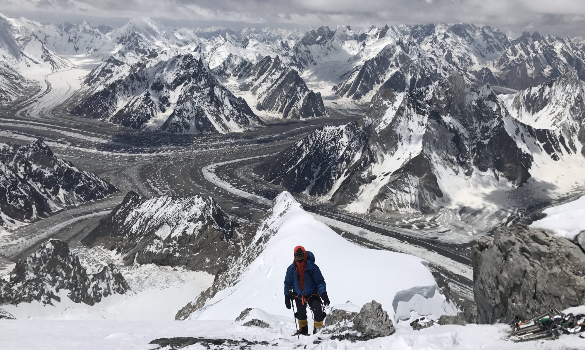
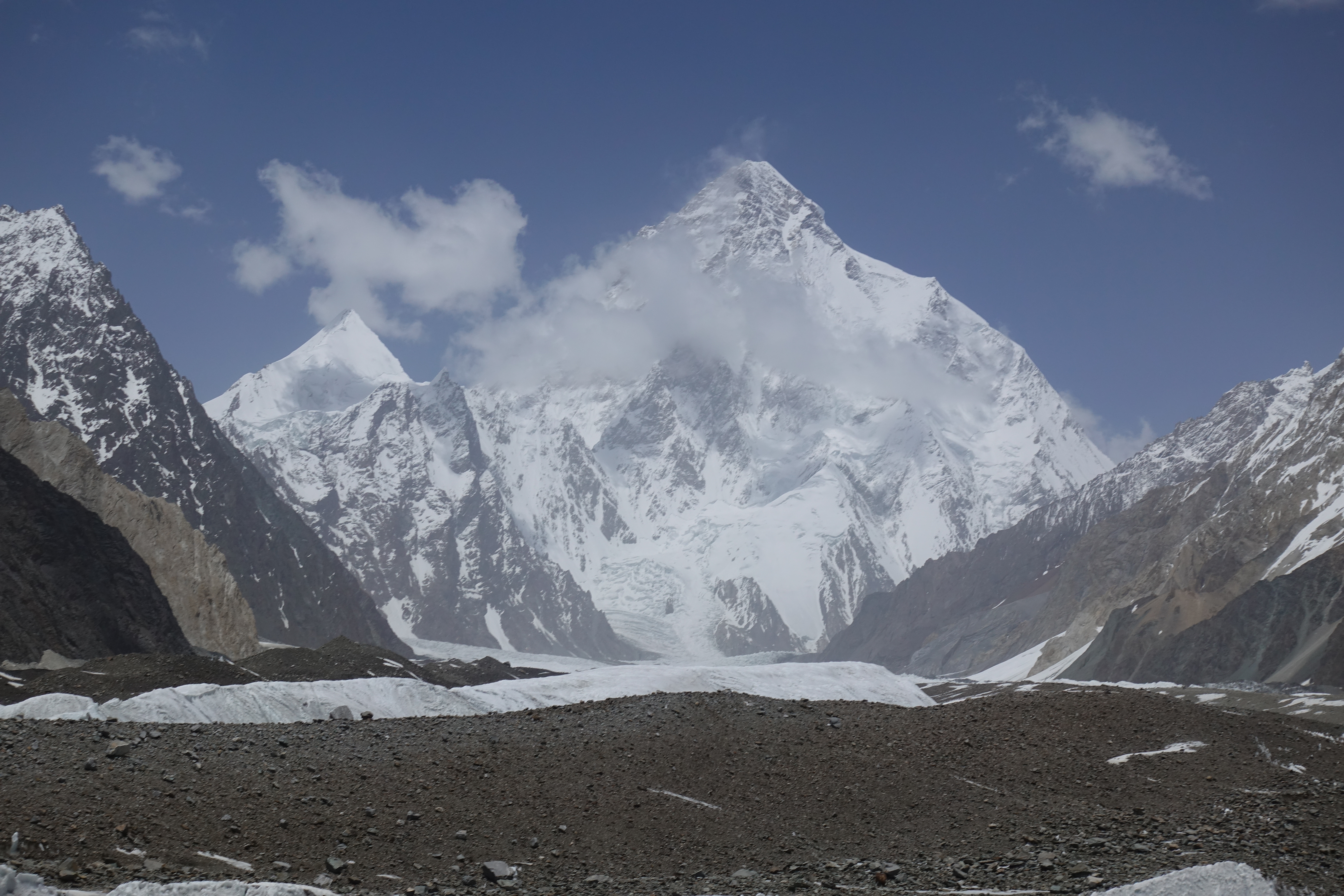
Since my visit to Pakistan two years ago I have been pretty gripped by the mountains and landscape of the northern part Gilgit-Baltistan. A rare and wild country with gorgeous mountain sceneries. Mostly, the incredible, breathtaking and mighty K2 has been stuck in my mind, more so since we then had had to turn around at camp 2 due to non-favorable conditions in 2017. But once you see the K2 (from Concordia) live and in full view, you fully understand why famed mountaineer Reinhold Messner called K2 the „mountain of mountains“. At least to me it screams „climb me“. Many of you will remember this fascination and admiration for K2 from my presentation last year.
Thus, after some thought I decided some months ago to give the mighty K2 one more shot! And that’s why you are now reading this blog ;).
Some background information on K2
Where is K2 located?
The K2 mountain is with 8611m the second highest mountain on earth and usually considered more difficult and dangerous than Mount Everest. It is located on the border between Pakistan and China in the Karakoram mountain chain which stretches from Northwest in Western China over Northern Pakistan to Southeast in India about 700 km long and 100-150km wide, where to the Southeast the proper Himalaya region continues. Politically, Karakoram is located in the Northern part of the disputed Kashmir region. In square meters, the largest part of Karakoram is part of the autonomous region Gilgit-Baltistan in Northern Pakistan. K2 is part of the mountain range Baltoro Muztagh within Karakoram, this range contains four peaks above 8000m: K2, Gasherbrum I, Broad Peak, Gasherbrum II. They are all located within a few kilometers which is the highest density of 8000m peaks on earth!
Is Karakoram part of the Himalayas?
There are arguments both pro and contra whether the Karakoram should be considered part of the Himalayas. From a geological standpoint the Karakoram can be considered part of the Himalayas as for example the rock formations are rather similar. On the other side, Karakoram and Himalaya arose from different landmasses: Karakoram from the Asian landmass, Himalaya from the Indian subcontinent when they drifted onto each other.
In practice the Indus river valley is usually considered the separation between the Southeastern part of the Karakoram and the Northwestern part of the „proper“ Himalayas. Karakoram is geologically a very active area with the Indian subcontinent still drifting into the Asian landmass. This is the reason why Karakoram / Kashmir unfortunately sometimes experiences devastating earth quakes.
Is the Karakoram as accessible as Khumbu valley in Nepal?
Some of you might have visited the Khumbu valley in Nepal, e.g. for the Everest Basecamp Trek. Then you will have met a lot of fellow people who are doing the same thing ;). How is it in the Karakoram?
For the largest part, the Karakoram is pretty inaccessible for tourists / motorways. Only the Hunza valley is readily accessible via the Karakoram highway. Otherwise, the Karakoram is mostly reserved for mountaineering and trekking, involving long approaches, small roads only for jeeps, or treks by foot. This makes it harder to reach the cool places, but will have the wild mountains here most of the same time pretty much for yourself!
One reason for this difficult accessibility is also the fact that the Karakoram is one of the most heavily glaciated regions on earth, outside the Polar regions. About 30-50% are glaciated, compared with about 2% for the Alps. It also contains some of the longest glaciers on earth outside the Polar regions (up to 70km).
Where does the name „K2“ come from?
The name K2 stems from the British survey engineer Thomas George Montgomerie who surveyed the Karakoram peaks from a greater distance in 1856 and numbered them according to the height measurements: K1, K2, K3, etc. However, he made a mistake and labeled the Masherbrum mountain „K1“ believing this to be the highest Karakoram mountain which in reality is much lower than K2. To date, the K2 has kept its name or you could say has not really been named whereas most other „K“ mountains have received „proper“ names.
When was K2 climbed for the first time?
K2 was first climbed in 1954 by Achille Compagnoni und Lino Lacedelli, with supplemental oxygen. Interestingly, the second successful climb only took place in 1977, inter alia due to developments around the Second Indian-Pakistan war in 1965 where the region was blocked by the Pakistan government from 1961 to 1974. The first summit without supplemental oxygen took place in 1978.
The normal route up K2: Abruzzi spur
The normal way up K2 is the Southeast spur, the Abruzzi spur. So called because of the Italian Duke of Abruzzi who made first advances on K2 in 1909 via the Southeast ridge where the reached an altitude of about 6000m. It later turned out to be the easiest way to the summit. Check out the other routes from the South side here: https://de.wikipedia.org/wiki/K2#/media/Datei:K2_south_routes.jpg
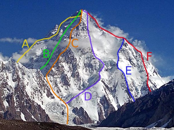
There are other ways up to K2 as you can see in the picture but they are very rarely used. C for example is the famous Magic Line which has only been climbed twice at all in the past fifty years. It involved climbing in the 6th difficulty degree on 8000m. D is the so called Polish line which has only been climbed once at all by two Polish alpinists. Messner called the line suicidal…
K2 can also be climbed from the North, from China. But this is a really long long and cumbersome expedition where it will take you at least two weeks to reach basecamp by foot, which involves crossing the Shaksgam river at a suitable place as there are no bridges. So this is a special endeavor rather reserved for professional alpinists or people with a looooot of time.
How to get to K2 basecamp for the Abruzzi spur:
In order to reach K2 basecamp for the Abruzzi spur you travel to Islamabad, the capital of Pakistan, then take a flight to Skardu (otherwise you have to travel two days in a bus on the Karakoram highway), from Skardu you go with a Jeep in about a day to Askole, and from Askole you then walk about three to four days via the mighty Baltoro glacier to Concordia ( https://en.wikipedia.org/wiki/Concordia_(Karakoram) ), then you turn left and continue several hours on the Godwin-Austen glacier until you reach K2 basecamp.
And now the journey begins. Check the following blog posts :).